13\05\2012
Written by Jurriaan
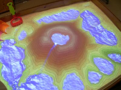
The Augmented Reality Sandbox
Oliver Kreylos has designed an augmented reality sandbox that projects a coloured topographic map in real time. This means contour lines and different colours, such as virtual water, appear while the sand is being manipulated.
The project is part of the University’s Keck Center for Active Visualization in the Earth Sciences, funded by the National Science Foundation in order to teach kids how land and water systems work.

The augmented reality sandbox is created using a Kinect 3D camera, a digital projector and simulation software running on a computer and an ordinary sandbox.
The Kinect camera is collecting images of the sandbox from above at thirty frames a second. These images are transferred to a computer running simulation software that will generate the different colours that represent different levels on the virtual map.
Realistic water movements are created using a set of Saint-Venant shallow water equations. By projecting everything in real time onto the sandbox, it appears as if hills, vulcano’s and rivers can be created in the sand.